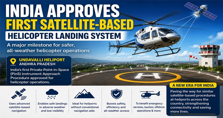
New Delhi: India has taken a significant step towards modernising its aviation infrastructure with the approval of the country’s first-ever satellite-based Private Point-in-Space (PinS) Instrument Approach Procedure for helicopter operations. The system, approved for Undavalli Heliport in Andhra Pradesh, is expected to make helicopter landings safer, more accurate and reliable, particularly in challenging weather conditions and remote locations.
The next time you fly, India’s space technology could help bring your aircraft safely to the ground.
For the first time, a commercial jet in India successfully landed using GAGAN, ISRO’s indigenous satellite navigation system, marking a major milestone for Indian aviation.… pic.twitter.com/u1ihoChgBy
— The Better India (@thebetterindia) July 1, 2026
Developed by the Airports Authority of India (AAI) and approved by the Directorate General of Civil Aviation (DGCA), the PinS procedure uses advanced satellite-based navigation technology to guide helicopters during instrument approaches. Unlike conventional systems that depend on costly ground-based navigation infrastructure, PinS enables pilots to carry out precise landings even at heliports where such facilities do not exist.
Ministry of Civil Aviation is pleased to announce a significant milestone in India’s aviation sector with the approval of the country’s first Private Point-in-Space (PinS) Instrument Approach Procedure for helicopter operations at Undavalli Heliport.
Developed by the Airports…
— PIB India (@PIB_India) July 2, 2026
The breakthrough aligns with global aviation standards and represents a major advancement in India’s efforts to adopt Performance-Based Navigation (PBN) technologies. It is expected to significantly enhance operational safety while improving accessibility to heliports located in difficult terrains, hilly regions and other underserved areas.
🚨🇮🇳 BIG: India achieves first-ever commercial satellite-guided jet landing using indigenous GAGAN system
🔸Successful IndiGo landing at Udaipur Airport.
🔸GAGAN = India’s own GPS Aided GEO Augmented Navigation.
🔸Precision approaches with minimal ground infrastructure.… pic.twitter.com/vvZzg8vh0H
— Sputnik India (@Sputnik_India) June 30, 2026
Civil Aviation Minister Ram Mohan Naidu described the approval as the beginning of a new chapter in India’s helicopter ecosystem. He said the initiative would strengthen flight safety, improve operational efficiency and enable all-weather helicopter services. The minister reiterated the government’s commitment to embracing advanced aviation technologies and building a world-class, technology-driven helicopter network.
Industry experts believe the new navigation system could be a game-changer for sectors that depend heavily on helicopter services. These include emergency medical evacuations, disaster management and rescue missions, offshore oil and gas operations, tourism, pilgrimage services such as the Char Dham Yatra, corporate aviation and regional air connectivity.
The approval also reflects India’s broader push towards satellite-enabled aviation systems and indigenous navigation capabilities, reducing dependence on traditional landing infrastructure while enhancing efficiency across the civil aviation sector.
With the successful implementation at Undavalli Heliport, similar PinS procedures are expected to be introduced at heliports across the country in the coming years. The move is likely to improve the safety, reliability and accessibility of helicopter operations, especially in regions where weather conditions and geographical challenges have traditionally limited air connectivity.