
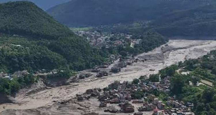
Nepal-China flash floods kill scores and leave hundreds missing as a glacier collapse devastates Rasuwa and Tibet, raising wider Himalayan flood risks.

A catastrophic flash flood and landslide disaster along the Nepal-China border has turned into one of the most serious Himalayan emergencies in recent years, with the death toll rising and more than 1,300 people reported missing across Nepal and China’s Tibet Autonomous Region.
The disaster struck on Wednesday, August 26, after a massive collapse of ice, rock and debris in the high Himalayas sent a sudden surge through the Lhende-Bhote Koshi river corridor. Entire settlements, roads, bridges and infrastructure were swept away or buried under mud and debris.
The latest reports indicate that at least 165 people have died in Nepal, while China has confirmed three deaths. The number of missing has risen sharply as authorities expand their searches: the latest Chinese update puts the number missing on its side at 558, while more than 800 people are reported missing in Nepal. Reuters reported that the combined number missing across the two countries was approaching 1,500 as rescue operations continued.
The crisis is still unfolding, and casualty figures are expected to change as rescuers reach isolated areas.
The earthquake theory has been overturned
One of the most important developments has been the clarification of what caused the disaster.
Initial seismic signals were interpreted as a possible magnitude 4.4 earthquake, raising fears that an earthquake-triggered landslide had generated the flood. However, subsequent analysis by the U.S. Geological Survey (USGS) found that the seismic signal was generated by a glacial collapse and debris flow rather than a conventional tectonic earthquake. The event has been characterised as a magnitude 5.2 glacial-collapse/landslide seismic event.
Satellite observations and scientific assessments indicate that a large mass of ice and rock collapsed at high altitude, blocking or obstructing the Lhende Khola, before the accumulated water and debris were released downstream.
That distinction matters. The disaster was not simply an earthquake followed by a flood. It appears to have been a cascading mountain hazard, in which unstable ice and rock generated a river blockage and an enormous downstream flood surge.
A massive flash flood in the Himalayan border areas of Nepal and China’s Tibet washed away villages while damaging roads, bridges and power projects in a region bordering Tibet, authorities said. More than 1000 people missing and 100 dead.
Footage from Nepal’s Rasuwa districts. https://t.co/9N2Ua5lIj0 pic.twitter.com/qc3nNKfV9Q
— Nature is Great (@GreatNature_) August 26, 2026
Nepal bears the heaviest destruction
Nepal’s Rasuwa district has been among the worst affected, with the flood racing through the Bhote Koshi corridor and reaching downstream areas including Nuwakot.
Communities around Timure, Rasuwagadhi and Syapru Besi suffered extensive destruction. Homes, bridges, roads, power facilities and other infrastructure were damaged or swept away.
The region is also an important gateway for people travelling towards Tibet and Mount Kailash, making the humanitarian situation particularly complex.
Nepalese authorities have reported hundreds of tourists and pilgrims missing. Many are foreign nationals, including Indians and visitors from several Western countries. Earlier official figures put the number of missing foreign tourists at more than 400, but the overall missing count has continued to rise as authorities consolidate information from affected areas.
Rescue teams are operating under extremely difficult conditions because roads and bridges have disappeared, communications have been disrupted and several locations remain inaccessible.
More than 5,000 rescue personnel have reportedly been involved in search-and-rescue operations, with helicopters being used to evacuate stranded people and deliver emergency supplies.
Tibet’s Gyirong Port becomes a second disaster zone
The catastrophe did not stop at the international boundary.
Across the border, Gyirong County and Gyirong Port in China’s Xizang Autonomous Region were badly affected by the mudslide and flood.
China initially reported three deaths and 265 missing people. On Thursday, however, the number of missing on the Chinese side was revised sharply upward to 558, reflecting the expansion of search operations and improved accounting.
The disaster cut roads leading to the border port and disrupted electricity and communications. Chinese authorities activated a Level-II emergency response for geological disasters and disaster relief, while rescue, military, firefighting and engineering teams were deployed.
A particularly worrying development is the reported formation of a barrier lake near Gyirong Port, creating the possibility of another sudden release of water if the temporary blockage fails.
That makes the current emergency more than a search-and-rescue operation. Authorities must simultaneously deal with the possibility of secondary flooding and further landslides.
The warning of another flood wave
The prospect of a second surge is now one of the biggest concerns.
When ice, rock and mud block a mountain river, water can accumulate behind the obstruction. If the temporary dam suddenly collapses, a second flood wave can travel downstream with little warning.
Authorities on both sides have therefore warned people to remain away from vulnerable riverbanks and continue monitoring the river system.
The presence of a barrier lake near Gyirong reinforces those concerns.
The lesson is stark: the first flood may be over, but the mountain system can remain unstable long after the initial collapse.
A grim reminder from the July 2025 disaster
The latest catastrophe also comes just over a year after another deadly glacial flood struck the same broader China-Nepal Himalayan corridor.
In July 2025, a giant supraglacial lake on the Purepu Glacier in Tibet burst, sending a powerful flood downstream through the Lhende catchment. The flood destroyed the China-Nepal Friendship Bridge at Rasuwagadhi and caused deaths and major infrastructure damage.
New scientific research published in 2026 has reconstructed that event in considerable detail. Researchers found that a supraglacial lake of roughly 0.68 square kilometres released about 7.22 million cubic metres of water within approximately 35 hours, producing severe downstream impacts.
Another study has highlighted a worrying monitoring gap: the 2025 Purepu lake was not adequately captured by existing hazard databases before it burst, despite the availability of satellite monitoring technology. Researchers argue that the transition from scientific monitoring to operational early-warning systems remains a major challenge.
That history makes the August 2026 disaster particularly significant. It suggests that this is not an isolated Himalayan anomaly but part of a rapidly evolving hazard environment.
Climate change is making the Himalayan risk harder to ignore
Scientists caution against attributing every individual glacier collapse directly to climate change. The precise trigger of the latest collapse is still being investigated.
But the broader climate signal is increasingly difficult to dismiss.
Warming is altering glaciers, snowfields, permafrost and high-altitude slopes across the Hindu Kush Himalaya. These changes can contribute to unstable ice and rock formations, changing drainage networks and the formation or rapid growth of glacial and supraglacial lakes.
Research into the 2025 China-Nepal floods found that unusually large supraglacial lakes can develop through a combination of glacier-wide melting, unstable drainage systems, ice-dam failure, hydrofracturing and short-term weather forcing, with longer-term climatic changes increasing the background risk.
The danger therefore comes not from one phenomenon alone, but from the way several processes can combine:
ice instability → avalanche or collapse → river blockage → sudden release → flash flood → landslide and debris flow → destruction downstream.
India also moves to high alert
The disaster has triggered concern downstream in India because Himalayan rivers ultimately cross into the country.
The Indian government said it was closely monitoring the situation and placed NDRF teams and local administrations in vulnerable border areas of Bihar and Uttar Pradesh on high alert. Union Home Minister Amit Shah spoke with the chief ministers of both states following the Nepal disaster.
Authorities in Bihar and Uttar Pradesh have been monitoring river levels and preparing for possible downstream effects.
At the same time, officials have indicated that the immediate threat to parts of Uttar Pradesh may be limited because the Gandak River was expected to remain below danger levels, although monitoring continues.
This underlines another reality of Himalayan disasters: a flood originating hundreds of kilometres upstream can become a regional emergency involving several countries.
What about Bhutan?
Bhutan has not been reported as directly affected by this particular Nepal-Tibet disaster.
But the Himalayan warning applies equally to Bhutan.
The country is highly exposed to glacial lake outburst floods, flash floods, landslides and other high-altitude hazards. Its steep valleys mean that a sudden release of water from a glacier or unstable mountain lake can travel rapidly towards populated areas and critical infrastructure.
Bhutan’s experience with the devastating 1994 GLOF remains a reminder of the destructive potential of high-altitude water bodies.
The significance of the Nepal-China disaster for Bhutan is therefore not that the same flood is moving towards Bhutan. It is that the same class of Himalayan hazards exists across national boundaries.
A glacier does not recognise a border. Neither does a river.
The real Himalayan challenge is information sharing
The latest disaster raises an uncomfortable question for Nepal, China, Bhutan and India: Can Himalayan countries exchange hazard information quickly enough to save lives?
Satellite technology can now identify changes in glacier lakes, ice movement and mountain slopes. River sensors can provide information about rapidly rising water levels. Remote sensing can detect changes even in inaccessible areas.
Yet technology is useful only if warnings reach people in time.
The 2025 Purepu disaster demonstrated how quickly a relatively remote high-altitude lake can turn into a transboundary catastrophe. The 2026 disaster has now shown the same vulnerability on an even larger scale.
The region urgently needs stronger systems for:
- real-time monitoring of glacial and supraglacial lakes;
- satellite-based detection of unstable ice and rock masses;
- automatic river-level and flood sensors;
- rapid cross-border exchange of warnings;
- coordinated emergency drills;
- evacuation routes for mountain communities; and
- clear protocols for warning downstream populations when a hazard originates across a border.
One disaster, a Himalayan-wide warning
For Nepal, the immediate challenge is saving lives, locating missing people and restoring destroyed transport and power infrastructure.
For China’s Tibet region, the priority is rescue at Gyirong, restoring the strategic border corridor and managing the newly reported barrier lake and other secondary hazards.
For India, the disaster is another reminder that Himalayan flood emergencies can quickly become downstream river-management problems.
For Bhutan, it is a warning to strengthen monitoring and preparedness for glacial lake and slope failures before they become disasters.
And for the Himalayas as a whole, the message is unmistakable.
The August 2026 Nepal-China catastrophe is not simply a flood. It is a demonstration of how ice, rock, water and a warming mountain environment can combine to create a disaster that crosses borders in minutes.
The immediate trigger appears to have been a glacial collapse/ice-rock avalanche and resulting debris flow, rather than a conventional earthquake. But the larger danger lies in what comes next: more unstable glaciers, more unpredictable high-altitude water bodies and more infrastructure occupying vulnerable river corridors.
The Himalayas are politically divided by borders. Their rivers, glaciers and hazards are not.